
Leica DISTO™ Plan
3.2.3 by Leica Geosystems AG (0 Reviews) April 26, 2026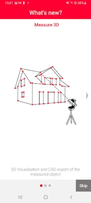
Latest Version
3.2.3
April 26, 2026
Leica Geosystems AG
Tools
Android
0
Free
com.leica.distoplan
Report a Problem
More About Leica DISTO™ Plan
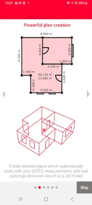
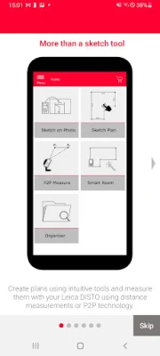
Sketch Plan is a mobile application that allows users to create scale drawings using their smartphone or tablet. With just their fingers, users can sketch out a floor plan and then take measurements to assign to the relevant lines. The app's 'Auto-Scale' function automatically adjusts the length of the lines to produce a scaled drawing, showing the surface area and circumference. For even more accuracy, the app also offers a 'Diagonals' feature.
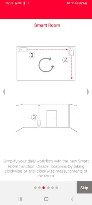
Smart Room is another feature of the app that allows users to create accurate floor plans by simply taking clockwise or counterclockwise measurements of a room. Once all measurements are taken, the app automatically generates the plan and the 'Diagonals' feature can be used to further enhance accuracy.
With the 'Sketch on Photo' feature, users can use Leica DISTO™ Bluetooth® technology to assign distance measurements to a picture taken with their device. This allows for easy documentation of measurement results and the ability to process them later in the office.
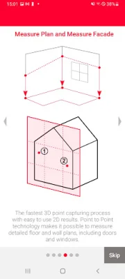
Measure Plan is a feature that supports P2P technology, making it possible to create detailed floor or wall plans, including doors and windows. These plans can then be exported as a DXF or DWG file into a preferred CAD solution.
For those needing to create detailed wall layouts, the 'Measure Façade' feature is designed for measuring 2D plans on vertical surfaces. By defining a vertical plane, all measured points can be automatically projected onto it for precision and clarity. Plans can then be exported as a DXF or DWG file into a preferred CAD program.
The 'Earthworks' feature uses P2P technology to calculate precise excavation volumes, making it useful for purposes such as billing and transport cost estimation. Users can measure the outline of the desired excavation and set the depth, as well as define various angles for the slope.
For those needing to create 3D plans, the 'Measure 3D' feature allows for accurate 3D plans to be generated and seamlessly integrated into CAD. P2P technology can be used for real-time 3D measurement visualization on-site, and measurements can be exported as a DXF or DWG file or as a detailed PDF report.
The 'Relocation' feature allows for project flexibility by enabling users to shift their setup to a new location and seamlessly integrate data into their existing drawing. This is useful in situations where all necessary measurements cannot be acquired from a single setup.
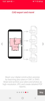
All measurements and floor plans can be exported in standard formats, including CAD drawings, JPG, and PDF. This allows for seamless integration of measurement data with digitized construction. The app supports a wide range of Leica DISTO™ devices, making it accessible to a variety of users.
Rate the App


Popular Apps